Wind Predictions in Tarifa: How to Read the Wind Forecast with Windguru
Tarifa is located at the southern tip of Europe, separated from Africa by the Strait of Gibraltar. Throughout the year, the temperature generally varies from 11°C to 27°C and rarely drops below 8°C or rises above 29°C. Here, the Mediterranean Sea and the Atlantic Ocean converge, allowing Tarifa to enjoy more than 300 days of wind per year. This is due to its geographical position in the Strait of Gibraltar, where the wind accelerates due to the physical phenomenon known as the Venturi Effect. Thanks to this natural funnel, the average wind speed in Tarifa usually exceeds 22 km/h and can reach gusts that exceed 109 km/h, making Tarifa a mecca for wind sports.
That’s why, before coming to Tarifa, it’s very common to check the wind predictions. However, it’s not always easy to interpret the graph. Many students and people often ask us how to interpret wind forecasts in apps like Windfinder, Windguru, or Windy.
We’ll explain how to interpret the wind forecast with Windguru in a simple, quick, and effective way.
First and foremost:
In Tarifa, we have 2 types of winds: Levante and Poniente.
Levante: It’s an east wind that blows offshore, usually intensely throughout the day. This wind is often warm and dry and can have strong gusts.
Poniente: It’s a west wind that comes from the Atlantic Ocean, blowing onshore or side onshore. It’s usually more humid and fresh.
How to read the wind forecast in Tarifa:
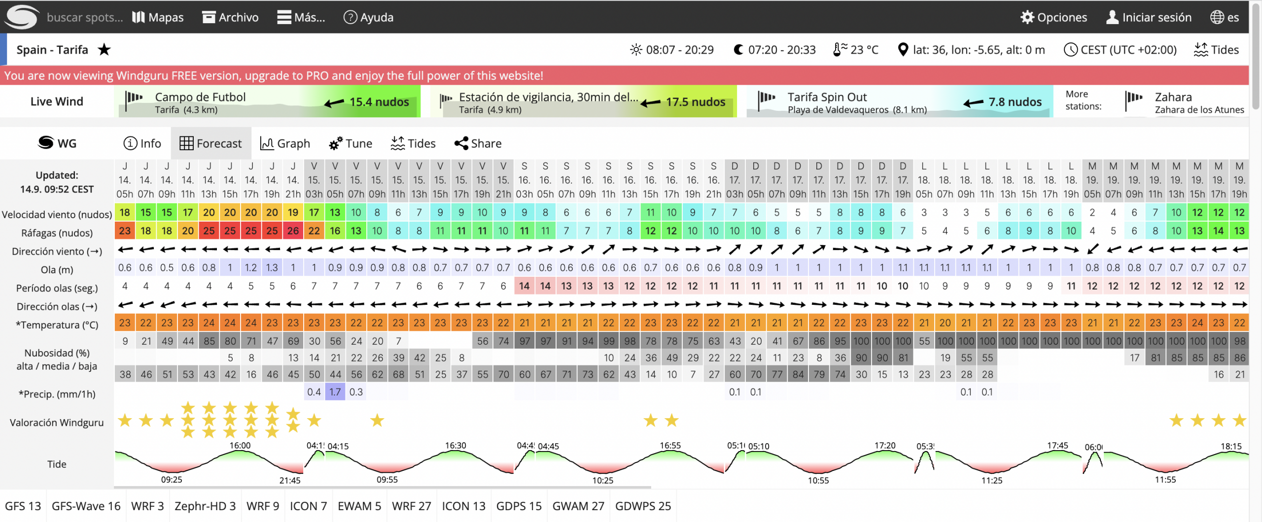
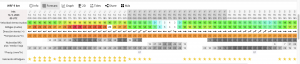
We use the Windguru website, which is the most commonly used.
The first step is to choose which model to look at. We recommend focusing on 3 main models:
The first one is the WG (it’s the table that appears first on Windguru).
It represents a weighted average of all the models in Windguru. It’s not very precise, but it provides a general and clear overview of the forecast for the upcoming week.
WRF 3km/WRF 9km (Weather Research and Forecasting with a 3 km or 9 km resolution): These models offer higher resolution, which means they provide more precise details about wind conditions in smaller areas. The WRF 3km model is particularly useful when you want detailed wind information for specific or local areas on the upcoming days. On the other hand, the WRF 9km model strikes a balance between resolution and coverage, offering a more detailed view while still covering a larger area compared to the WRF 3km.
WRF 9KM
WRF 3KM
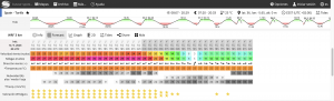
In summary, if you need precise details about wind conditions in a specific location or local area, opt for higher-resolution models like WRF 3km or WRF 9km. If you’re looking for a general overview in a broader area, WG may suffice.
The next step is to focus on 3 main factors: Wind Direction, Wind Strength, and Cloud Coverage:
Wind Direction: If the arrows point to the left, it’s Levante wind; if they point to the right, it’s Poniente wind. It’s that simple.
Wind Strength with Gusts: The color and the number provide an indication of wind speed. The higher the number, and the more it leans toward warm colors, the stronger the wind will be. Gusts indicate a momentary and sudden increase in wind speed, which is higher than the average wind speed during a specific period.
Cloud Coverage: It tells us how many clouds are present. Generally, the cloudier it is, the more gusty the wind will be.
Wind Forecast with Levante Wind:
With this wind direction, it’s very rare for the forecast to be wrong, but it often underestimates the wind speed by 5 to 10 knots. In other words, if you see the forecast indicating 10-11 knots, it will be enough to go out on the water.
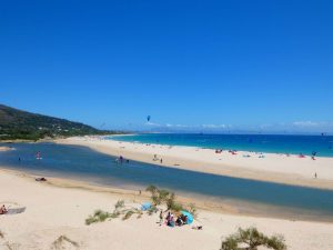
There are two main spots for safe sailing with Levante wind: Los Lances Beach and Valdevaqueros Beach.
At Los Lances Beach, the wind generally blows in an entirely offshore direction, and you’ll need a rescue card in case of any issues. Two rescue boat companies operate from 11 in the morning until 8 in the evening (summer hours, with reduced hours in winter and no service in January and February).
At Valdevaqueros Beach, it’s not essential to have a rescue boat card because of the beach’s shape and wind direction. There’s a dune at the end, and if you encounter any problems, you’ll reach solid ground.
Things to keep in mind:
- For forecasts indicating over 30 knots and with red or purple colors, you can head to spots on the Costa de la Luz, like Caños de Meca (45 minutes from Tarifa), Rota (1 hour and 30 minutes from Tarifa), or in the Mediterranean area, Getares (20 minutes) and Palmones (30 minutes) in Algeciras, where you’ll find much less wind. Note that during the high season, it’s not allowed to sail at these spots.
- The first days of Levante tend to be more gusty, especially if the sky is cloudy. The last days of Levante, when it weakens, especially in summer, the Levante wind shifts more towards the south and often becomes more side-on (especially at Valdevaqueros Beach) and more constant.
- Between tides, especially with the tide rising, Levante wind can increase by 1 to 5 knots.
- With this wind, wing sizes between 2 and 4 meters are used (if the wind is stronger, sizes from 4 to 5.5 meters may also be suitable).
Wind Forecast with Poniente Wind:
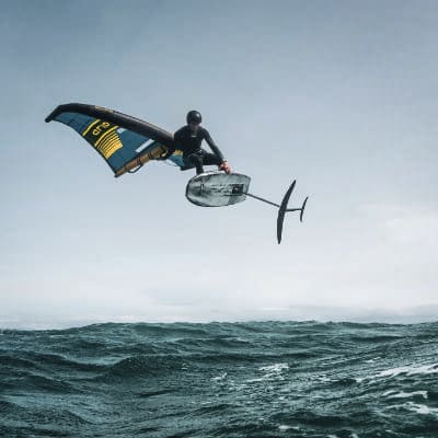
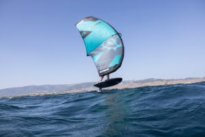
Wing foil Valdevaqueros spot Tarifa
Poniente wind typically has a low to medium intensity in the summer with calm seas, while in winter, it becomes stronger with the presence of waves.
It always works with forecasts indicating more than 10 knots at a minimum, and in the summer, on sunny days, it can be reinforced by thermal winds. On cloudy days, it often fails to materialize. The main spots for sailing are Los Lances Beach and Valdevaqueros Beach.
In general, during the summer months, it works much better at Valdevaqueros Beach. Many times, even when there’s no official forecast, if the sky is clear in the afternoon, thermal winds from 15 to 20 knots often kick in. If the wind direction is more northward (which typically happens more during the winter season), then Los Lances Beach becomes a better option.
Generally, with this wind, wing sizes between 4 and 6 meters are used, and smaller sizes are rarely required.
Final Tips:
Always check the WG table for a general idea of the Tarifa forecast, and a few days before your session, consult the detailed forecast, such as the 9 WRF and 3 WRF, for confirmation. If you’re a beginner looking to take a wingfoil course in Tarifa, feel free to contact us, and we’ll advise you on when to come and what type of course you need. If you’re already experienced and want to sail independently but have questions, you’re also welcome, and we’ll be happy to answer any inquiries you may have.